
Summit County Maps: Breckenridge, Keystone, Frisco and More
Summit County looks compact on a Colorado map. The practical version is more spread out. Breckenridge sits south of I-70, Keystone lies east of Dillon, and Copper Mountain is west of Frisco. Choosing the wrong base can add a cross-county drive to every ski morning.
The easiest way to understand the region is to ignore town boundaries at first. Use I-70 as the east-to-west line, Dillon Reservoir as the central landmark, and three highway exits as your reference points.
Summit County in One Minute
Driving west from Denver, Exit 205 serves Silverthorne, Dillon and the road to Keystone. Exit 203 serves Frisco and the turn south to Breckenridge. Exit 195 leads directly to Copper Mountain. Dillon Reservoir sits between the eastern and western groups: Dillon is on its eastern side, Frisco is on the west, and Silverthorne is just north of the I-70 interchange.
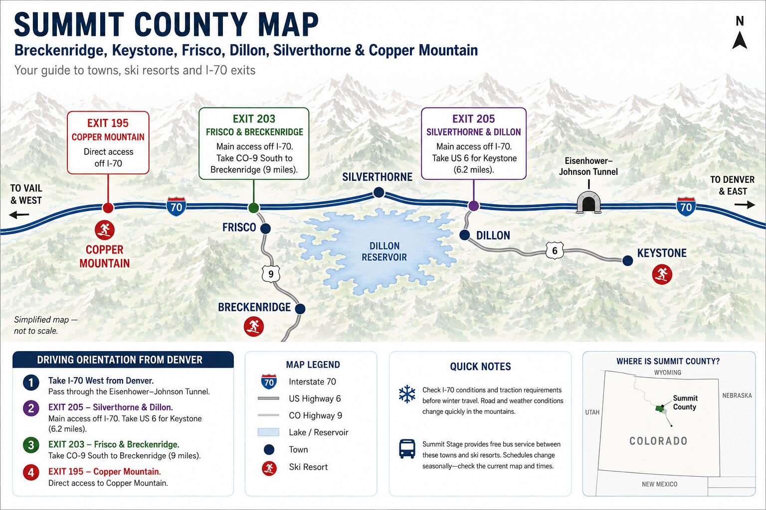
A Simple East-to-West Map
This is the basic road order when approaching Summit County from Denver:
Denver → I-70 West → Eisenhower–Johnson Tunnel → Exit 205 → Exit 203 → Exit 195
- Exit 205: Silverthorne, Dillon and US 6 toward Keystone
- Exit 203: Frisco and CO-9 south toward Breckenridge
- Exit 195: Copper Mountain
The order matters. Keystone is reached before Frisco when arriving from Denver, but it sits several miles away from I-70. Breckenridge appears later in the journey because the turn is at Frisco, followed by another drive south. Copper is the farthest west of the six places covered here.
Use I-70 and Dillon Reservoir as Your Landmarks
I-70 is the main road into and across the county. It connects Silverthorne, Frisco and Copper Mountain, then continues west toward Vail. Breckenridge and Keystone branch away from it in opposite directions.
Dillon Reservoir helps make sense of the towns around the center of the county. Dillon occupies the eastern side of the reservoir. Frisco sits near its western and southwestern shore. Silverthorne is north of the water and north of I-70.
This explains why Dillon and Frisco look close on a regional map but are not connected by a road straight across the lake. Drivers follow the roads around it. The two towns even have separate marinas on opposite sides of the reservoir.
| Place | Position on the map | Main road or exit | Geographic advantage |
|---|---|---|---|
| Silverthorne | North of I-70 at the eastern entrance to the main county corridor | Exit 205 / CO-9 | Easy arrival from Denver, shopping and access toward Keystone |
| Dillon | South and east of Exit 205, beside Dillon Reservoir | Exit 205 / US 6 | Convenient for Keystone and reservoir activities |
| Keystone | East of Dillon along US 6 | Exit 205, then US 6 East | Best for a Keystone-focused stay and access toward Arapahoe Basin |
| Frisco | West side of Dillon Reservoir beside I-70 | Exit 203 | Central base for trips to several resorts |
| Breckenridge | South of Frisco and I-70 | Exit 203, then CO-9 South | Best when most days will be spent in Breckenridge |
| Copper Mountain | West of Frisco directly beside I-70 | Exit 195 | Simple highway access and lodging at the resort |
Exit 205: Silverthorne, Dillon and Keystone
Exit 205 is the first major Summit County junction after descending from the Eisenhower–Johnson Tunnel. Silverthorne and Dillon share the exit, which is why accommodation searches often group them together.
They are still separate towns. Silverthorne is mainly north of I-70. Dillon lies south of the interchange and about a mile east along Highway 6. A hotel described as being in the “Dillon–Silverthorne area” may not be within a comfortable walk of Dillon Marina, Silverthorne’s shops or the bus stop you intend to use.
Keystone is farther east on US 6. From Exit 205, the official resort directions continue for about 6.2 miles. The road passes through Dillon and follows the valley toward the resort.
Keystone itself is spread out. River Run Village, Mountain House, Lakeside Village and residential areas are not one compact block. A regional map gets you to Keystone; a resort base map is needed for the correct parking lot, lift or check-in desk.
Exit 203: Frisco and Breckenridge
Frisco is close to Exit 203. Main Street lies roughly half a mile south of I-70, and Frisco Bay Marina is on the nearby shore of Dillon Reservoir.
Breckenridge uses the same exit but is not beside the interstate. After leaving I-70, drivers follow CO-9 south through Frisco and continue for roughly nine miles. This section can be quick on a quiet summer morning and much slower during a snowy ski weekend.
Frisco’s position makes it a practical base for travellers who plan to divide their days between Breckenridge, Copper and the eastern side of the county. It has no large downhill ski resort of its own. Its strength is the road network.
Breckenridge works differently. Staying there removes the daily CO-9 drive when Breckenridge is the main destination, but adds distance when the group wants to visit Keystone or Copper repeatedly.
Exit 195: Copper Mountain
Copper Mountain sits directly beside I-70 at Exit 195, west of Frisco. There is no long approach road comparable to the routes into Breckenridge or Keystone.
The resort is simple to place on a regional map and less simple once you arrive. Copper has several base areas, including East Village, Center Village and West Village. Parking and lift access depend on what you are doing that day.
Use the county map to reach Exit 195, then switch to Copper’s current village and parking map. A skier heading for beginner terrain may need a different lot from someone meeting friends near Center Village.
Driving from Denver to Summit County
The standard route from Denver and Denver International Airport is I-70 West. The road climbs through the mountain corridor, passes through the Eisenhower–Johnson Tunnel and descends toward Silverthorne.
The destinations are in roughly the same 90- to 105-mile corridor from DEN, depending on the endpoint. Those figures are useful for orientation, not arrival planning. Traffic, snow, crashes and tunnel metering can change the trip far more than a ten-mile difference between towns.
The Main Route from Denver
- Take I-70 West. Check current road conditions before leaving Denver or the airport rather than relying only on the original navigation estimate.
- Pass through the Eisenhower–Johnson Tunnel. Silverthorne and the main Summit County junctions are reached after the descent.
- Use Exit 205 for Silverthorne, Dillon and Keystone. Continue east on US 6 for Dillon and Keystone.
- Use Exit 203 for Frisco and Breckenridge. Stay on CO-9 South for Breckenridge.
- Use Exit 195 for Copper Mountain. Follow the signs for the correct village or parking area after leaving I-70.
A clear-road estimate should never be treated as a deadline for a flight, lesson or restaurant reservation. Winter weekend traffic often builds westbound on Friday afternoon and Saturday morning, then eastbound on Sunday afternoon.
For travellers who prefer not to drive the mountain corridor after a flight, the guide to Denver airport transportation to Summit County compares shared shuttles, private transfers and rental cars.
Winter Roads Change the Map
- Navigation times can increase sharply during snow, crashes or heavy ski traffic.
- Colorado’s current traction requirements should be checked before driving I-70.
- An AWD rental car is not automatically ready for winter if its tires are unsuitable or worn.
- The Eisenhower–Johnson Tunnel may be metered during heavy traffic.
- A mountain pass suggested as a detour may be slower and more difficult than waiting on I-70.
- Check live conditions through COtrip before leaving Denver and again before returning.
During severe storms, CDOT can activate the Passenger Vehicle Chain Law, requiring chains or an approved alternative traction device. Road closures are also possible. A navigation app cannot guarantee that a proposed detour over a pass is open or sensible.
Places That Look Closer Than They Are
Breckenridge and Keystone
The two resorts appear close when looking across the mountains. There is no direct road over the ridge between them. Drivers use CO-9, Swan Mountain Road and US 6, or travel through the Frisco and Dillon side of the road network.
They can be combined in one trip. Switching between them every morning is less convenient than staying at one resort and visiting the other once.
Keystone and Copper Mountain
Both are in Summit County, yet they sit on opposite sides of the central corridor. Keystone lies east of Dillon. Copper is west of Frisco. The drive crosses much of the region and includes both US 6 and I-70.
Dillon and Frisco
The towns face different sides of Dillon Reservoir. The water makes the straight-line distance look short, but cars must use the roads around it. This matters when comparing a Dillon rental with ski equipment stored in Frisco.
Dillon and Silverthorne
They share Exit 205 and are close, though they are not one walkable resort village. I-70, the interchange and commercial roads divide the area. Check the exact address rather than judging the stay by the combined “Dillon/Silverthorne” label.
Choose Lodging by the Morning Drive
Open directions from the exact property to the lift, rental shop or bus stop you expect to use. “Located in Summit County” says very little about the morning routine. Frisco is often the neutral choice for a multi-resort trip. Breckenridge or Keystone makes more sense when nearly every day is tied to one mountain. The Summit County lodging guide compares those bases in more detail.
Getting Around Without a Car
Summit Stage provides free public bus service between towns and resorts across the county. Its network serves Breckenridge, Dillon, Frisco, Silverthorne, Copper Mountain and Keystone, with seasonal ski connections to the major mountains.
A car-free trip is possible, but it works best when planned around the bus map from the start. A low-priced condo on a hillside may be a poor choice if the nearest stop requires a long walk with skis and boots.
Routes and timetables change between summer and winter. Some journeys require a transfer in Frisco or Silverthorne. Check the current first and last departure times rather than assuming buses run late into the evening.
The resorts also operate local systems in their immediate areas. These help with movement between lodging, base villages and lifts, but they do not replace the full county network.
Which Map Do You Actually Need?
Regional Road Map
Use this to choose a town, understand I-70 exits and plan the drive from Denver. It should show Dillon Reservoir, the main highways and the six places covered on this page.
Resort Base Map
Use a resort map for parking, village names, hotel check-in and lift access. Breckenridge’s peaks, Keystone’s base areas and Copper’s villages each need their own detailed map.
Summit Stage Map
Use the current seasonal map when travelling without a car. Look at the actual stop names and transfer points. A bus line passing through a town does not mean it stops beside every accommodation property.
Trail and Recreation Map
For hiking, cycling and trailheads, use the official Summit County Interactive Trails Map. It distinguishes natural-surface trails, paved recreation paths, trailheads and approved uses. A standard road map does not show whether a trail allows bikes, horses or motorized vehicles.
For summer planning, the county’s recreation path system also helps connect parts of Frisco, Dillon, Silverthorne, Breckenridge and Keystone. It is a recreation network, not a substitute for the bus when carrying luggage.
Quick Base Choices
Mostly Breckenridge
Stay in Breckenridge or along the CO-9 corridor. There is little reason to add the Frisco-to-Breckenridge drive every morning solely to save a small amount on lodging.
Mostly Keystone
Keystone is the easiest base. Dillon and eastern Silverthorne can also work when the accommodation or restaurant choice is better.
Breckenridge and Copper Mountain
Frisco offers the most balanced road position. It lies near the turn to Breckenridge and a short I-70 drive from Copper.
Several Summit County Resorts
Frisco is usually the cleanest geographic compromise. It does not eliminate driving, but it avoids placing the group at the far eastern or southern edge of the map.
Staying at Copper Mountain
Choose Copper when most plans are at Copper. The direct I-70 location is convenient for arrival, though repeated trips to Keystone will cross the county.
Frequently Asked Questions
Is Breckenridge Right Off I-70?
No. Take Exit 203 at Frisco, then follow CO-9 South into Breckenridge. The final section is roughly nine miles.
Which Exit Is Used for Keystone?
Use Exit 205 for Silverthorne and Dillon, then follow US 6 East. Keystone Resort is about 6.2 miles from the interstate exit.
Are Dillon and Silverthorne the Same Town?
No. They share Exit 205 but occupy different sides of I-70 and have separate town centers. Combined accommodation listings can hide that difference.
Is Frisco a Ski Resort?
Frisco is a town and transport base rather than a large downhill ski resort. Its location is convenient for Breckenridge, Copper and other parts of Summit County.
Can Summit County Be Visited Without a Car?
Yes. Summit Stage is free and connects the main towns and ski areas. A car-free stay works best when accommodation, bus stops and daily activities are planned together. Late arrivals, remote rentals and frequent resort changes make a vehicle more useful.
Use the Map to Choose a Base
Use I-70 to understand the county, Dillon Reservoir to place the central towns, and the morning destination to choose accommodation. Exit 205 serves the eastern group, Exit 203 connects Frisco and Breckenridge, and Exit 195 leads to Copper. Once that pattern is clear, the region becomes much easier to plan.